
Prince Rupert topographic map
Click on the map to display elevation.
Prince Rupert
Prince Rupert Airport (YPR/CYPR) is on Digby Island. Its position is 54°17′10″N 130°26′41″W / 54.28611°N 130.44472°W / 54.28611; -130.44472, and its elevation is 35 m (115 ft)) above sea level. The airport consists of one runway, one passenger terminal, and two aircraft stands. Access to the airport is typically achieved by a bus connection that departs from downtown Prince Rupert (Highliner Hotel) and travels to Digby Island by ferry. The airport is served by Air Canada from Vancouver International Airport (YVR).
About this map
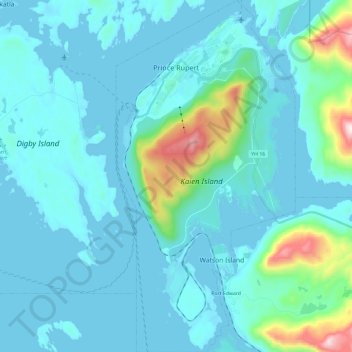
Name: Prince Rupert topographic map, elevation, terrain.
Average elevation: 299 ft
Minimum elevation: -13 ft
Maximum elevation: 2,589 ft
Other topographic maps
Click on a map to view its topography, its elevation and its terrain.
Edwards Islet
Canada > British Columbia > North Coast Regional District > Area C (South Skeena)
Average elevation: 85 ft
Kendrick Point
Canada > British Columbia > North Coast Regional District > Area E (Moresby Island)
Average elevation: 131 ft
Metlakatla
Canada > British Columbia > North Coast Regional District > Area A (North Skeena) > Metlakatla
Average elevation: 105 ft