Geolocate

Dicey topographic map

Click on the map to display elevation.

About this map

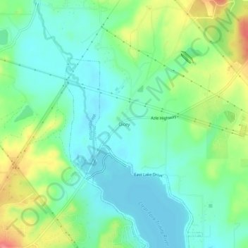
Name: Dicey topographic map, elevation, terrain.

Location: Dicey, Parker County, Texas, United States (32.78735 -97.71919 32.82735 -97.67919)

Average elevation: 971 ft

Minimum elevation: 892 ft

Maximum elevation: 1,138 ft

Parker County trails, hiking, mountain biking, running and outdoor activities

Other topographic maps

Click on a map to view its topography, its elevation and its terrain.

Cool

United States > Texas > Parker County

Average elevation: 932 ft

Sanctuary

United States > Texas > Parker County

Average elevation: 781 ft

Weatherford

United States > Texas > Parker County

Average elevation: 1,089 ft

Hudson Oaks

United States > Texas > Parker County

Average elevation: 978 ft

Weatherford

United States > Texas > Parker County

Average elevation: 1,070 ft

Gear up for your next adventure:

Camping Coffee Makers - Enjoy premium coffee at the summit or campsite
📡GPS Antenna Upgrade - Enhance GPS reception in remote terrain
🧭Pro Hiking Compasses - High-accuracy liquid-filled compasses for topographic orientation
📌Outdoor GPS Map App - Apps and devices for digital topographic navigation
GPS Sports Watch - GPS watch for running, hiking and training

As an Amazon Associate, this site earns from qualifying purchases at no extra cost to you.