Geolocate

Printer topographic map

Click on the map to display elevation.

About this map

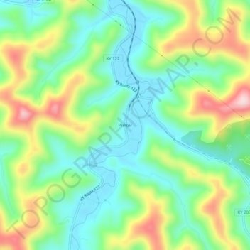
Name: Printer topographic map, elevation, terrain.

Location: Printer, Floyd County, Kentucky, 41655, United States (37.50982 -82.76627 37.54982 -82.72627)

Average elevation: 971 ft

Minimum elevation: 636 ft

Maximum elevation: 1,581 ft

Floyd County trails, hiking, mountain biking, running and outdoor activities

Other topographic maps

Click on a map to view its topography, its elevation and its terrain.

Wheelwright

United States > Kentucky > Floyd County

Average elevation: 1,460 ft

Allen

United States > Kentucky > Floyd County

Average elevation: 856 ft

Martin

United States > Kentucky > Floyd County

Average elevation: 883 ft

Gear up for your next adventure:

📻Weather Alert Radios - Stay informed of storm risks while off-the-grid
🧥Men's Rain Shells - Premium waterproof and breathable jackets for mountain weather
🎒Waterproof Dry Bags - Keep your electronics and maps dry inside your pack
🔦LED Headlamp - Bright and durable LED headlamp for night navigation
🪄Magnetic Compass - Accurate compass for navigation

As an Amazon Associate, this site earns from qualifying purchases at no extra cost to you.