
Chupaca topographic map
Click on the map to display elevation.
About this map
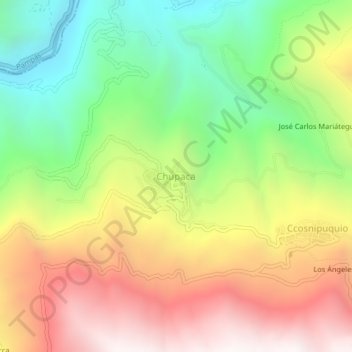
Name: Chupaca topographic map, elevation, terrain.
Location: Chupaca, Acoria, Huancavelica, Perú (-12.54222 -74.85022 -12.50222 -74.81022)
Average elevation: 11,381 ft
Minimum elevation: 8,924 ft
Maximum elevation: 14,140 ft
Other topographic maps
Click on a map to view its topography, its elevation and its terrain.
Ccochaccasa
El distrito abarca una superficie de 116,6 km² se encuentra ubicado al norte del Distrito de Lircay y a una distancia de 25 km; su capital está situada en plena carretera central Lircay - Huancavelica; su coordenada está comprendida en latitud sur de 12º 55’ 33” y longitud oeste de 74° 46’ 4”,…
Average elevation: 12,989 ft
Surcubamba
Ubicado a una altitud de 2 481 a 3 665 m.s.n.m.
Average elevation: 9,829 ft
Vilca
Vilca es un distrito en la Provincia de Huancavelica, situada a 3 275 m de altitud, en la falda norte del cerro Huamanrazo (5 278 m) a 157,6 km del distrito de Huancavelica. Los ríos Pachachaca y Ichu recorren el término municipal antes de unirse al Mantaro. Coordenadas Longitud oeste: 75° 10' 24(O) Latitud…
Average elevation: 13,570 ft
Huachocolpa
Huachocolpa es una localidad peruana, en la Provincia de Huancavelica, situada a 2 907 m de altitud, en la confluencia de los ríos Atoccmarca y Totora, cuenca del río Huachocolpa (5 278 m). El Huachocolpa recorre el término municipal antes de unirse al Mantaro. Coordenadas Longitud oeste: 75° 02'11 (O)…
Average elevation: 15,013 ft
Arma
El distrito de Arma tiene una extensión de 304.85 km², que representa el 7.7% de la superficie provincial y el 1.4% de la superficie regional. Su altitud fluctúa desde los 1 680 m s. n. m. hasta los 4 400 m s. n. m. En el distrito se ubican diferentes pisos altitudinales, con diversos caracteres…
Average elevation: 13,379 ft
Moya
Moya es una localidad peruana, en la provincia de Huancavelica, situada a 3 162 m de altitud, en la falda norte del cerro Huamanrazo (5 278 m). Los ríos Vilca y Moya recorren el término municipal antes de unirse al Mantaro. Coordenadas Longitud oeste: 75° 02' 12(O) Latitud sur: 12° 35' 27(S). Ubigeo: 090112
Average elevation: 13,009 ft
Laria
Laria es una localidad peruana, en la Provincia de Huancavelica, situada a 3 861 m de altitud, en la falda norte del cerro Huamanrazo (5 278 m). El río Huancavelica recorre el término municipal antes de unirse al Mantaro. Coordenadas Longitud oeste: 75° 02'11(O) Latitud sur: 12° 25' 51(S). Ubigeo: 090109.
Average elevation: 13,264 ft
Cuenca
Cuenca es una localidad peruana, en la Provincia de Huancavelica, situada a 3 167 m de altitud, en la falda norte del cerro Huamanrazo (5 278 m). El río Huancavelica recorre el término municipal antes de unirse al Mantaro. Coordenadas longitud oeste: 75° 02'11 (O) latitud sur: 12° 25' 51 10" (S). GUANACO,…
Average elevation: 12,283 ft
Acobambilla
San José de Acobambilla es una localidad del Perú, en la Provincia de Huancavelica, situada a 3 795 m de altitud, a 154,7 km de la capital provincial, en la falda norte del cerro Huamanrazo (5.278 m). El río Acobambilla recorre el término municipal antes de unirse al río Mantaro. Coordenadas Latitud: 12°…
Average elevation: 14,849 ft
Aurahuá
El distrito se encuentra en la región quechua, en la zona norte de la provincia de Castrovirreyna. Su territorio abarca altitudes que llegan hasta los 5224 m s. n. m. en la zona de Janca o Cordillera.
Average elevation: 14,193 ft
Colcabamba
El distrito de Colcabamba limita por el este con los distritos de Ayahuanco y Qhuinchihuasi, por el oeste con los distritos de Daniel Hernández y Pampas, por el norte con Surcobamba y Tinyaypuncu y por el sur con el distrito de Anco. La altitud promedio de la capital es de 2,972 m s. n. m. El punto más alto…
Average elevation: 10,367 ft
Ascensión
Ascensión es una localidad peruana, en la Provincia de Huancavelica, situada a 3 680 m de altitud, en la falda norte del cerro Huamanrazo (5.278 m). El río Huancavelica recorre el término municipal antes de unirse al Mantaro. Coordenadas 74Q56'47" (O) - 12Q36' 10" (S)
Average elevation: 15,075 ft
Paucará
Paucará cuenta con una superficie de 225 km² que representa el 24,77% del área de la provincia de Acobamba. Está situada a una altitud promedio de 3806 m s. n. m. Cuenta con centros educativos de los niveles iniciales, primarios y secundarios y con modernas instalaciones educativas.
Average elevation: 12,844 ft
Conayca
Conayca es una localidad del Perú, en la Provincia de Huancavelica; situada a 3 680 m de altitud; a 90,3 km de la capital provincial; en la falda norte del cerro Jhaullapa, vocablo quechua (de donde se ve todo) (5 278 m).
Average elevation: 12,211 ft
Huayllahuara
Huayllahuara es una localidad peruana, en la Provincia de Huancavelica, situada a 3 896 m de altitud, en la falda del cerro Hicho Urcco y Condori (5 278 m). Coordenadas Longitud oeste: 75° 02'11 (O) Latitud sur: 12° 25' 51 10" (S). Ubigeo: 090107.
Average elevation: 12,349 ft
Nuevo Occoro
Nuevo Occoro es una localidad peruana, en la Provincia de Huancavelica, situada a 3 825 m de altitud, en la falda norte del cerro Huamanrazo (5 278 m). Los ríos Pachachaca y Occoro recorren el término municipal antes de unirse al Mantaro. Coordenadas Longitud oeste: 75°2′12″(O) Latitud sur: 12° 35'…
Average elevation: 13,835 ft
Ahuaycha
Ubicado a una altitud de 3264 m s. n. m. Tiene una extensión de 90,96 km². Este distrito tiene 31 poblados en su territorio.
Average elevation: 12,096 ft
Izcuchaca
Izcuchaca es una localidad del Perú, en la Provincia de Huancavelica, situada a 2 880 m de altitud, a 78,0 km de la capital provincial, en la falda norte del cerro Huamanrazo (5.278 m). El río Acobambilla recorre el término municipal antes de unirse al río Mantaro. Coordenadas Latitud: 12°29′51″ S…
Average elevation: 11,266 ft
Yauli
El distrito de Yauli se encuentra en plena región quechua. Por lo tanto; la capital del distrito, se ubica a 3 385 metros sobre el nivel del mar. Presenta un variado biotopo y una gran diversidad de pisos ecológicos; con altitudes que varían entre los 3.100 y 4.700 m s. n. m.
Average elevation: 13,556 ft
Pampas
Su fisiografía está representada por el Valle Upamayo en donde se localiza la capital provincial, de relieve llano sin problemas de fenómenos de geodinámico externa; seguido por el paisaje colinoso de relieve moderado a empinado donde se producen fenómenos externos como derrumbes y deslizamientos. La…
Average elevation: 12,185 ft
Colcabamba
El distrito de Colcabamba limita por el este con los distritos de Ayahuanco y Qhuinchihuasi, por el oeste con los distritos de Daniel Hernández y Pampas, por el norte con Surcobamba y Tinyaypuncu y por el sur con el distrito de Anco. La altitud promedio de la capital es de 2,972 m s. n. m. El punto más alto…
Average elevation: 10,367 ft
Pampas
Su fisiografía está representada por el Valle Upamayo en donde se localiza la capital provincial, de relieve llano sin problemas de fenómenos de geodinámico externa; seguido por el paisaje colinoso de relieve moderado a empinado donde se producen fenómenos externos como derrumbes y deslizamientos. La…
Average elevation: 12,185 ft
Surcubamba
Ubicado a una altitud de 2 481 a 3 665 m s. n. m.
Average elevation: 9,829 ft
Yauli
El distrito de Yauli se encuentra en plena región quechua. Por lo tanto; la capital del distrito, se ubica a 3 385 metros sobre el nivel del mar. Presenta un variado biotopo y una gran diversidad de pisos ecológicos; con altitudes que varían entre los 3.100 y 4.700 m s. n. m.
Average elevation: 13,556 ft