Geolocate

Province of Chepén topographic map

Interactive map

Click on the map to display elevation.

About this map

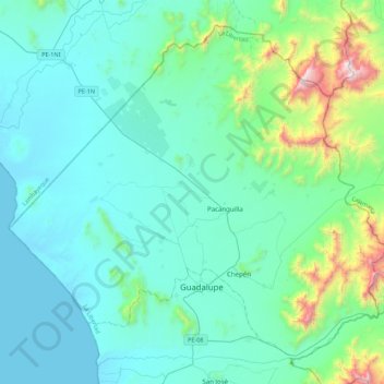
Name: Province of Chepén topographic map, elevation, terrain.

Location: Province of Chepén, La Libertad, Peru (-7.32524 -79.69062 -6.94624 -79.25180)

Average elevation: 728 ft

Minimum elevation: -3 ft

Maximum elevation: 5,098 ft

Other topographic maps

Click on a map to view its topography, its elevation and its terrain.

Nueva Esperanza

Peru > La Libertad

Average elevation: 128 ft

El Milagro

Peru > La Libertad

Average elevation: 495 ft

Piscopampa

Peru > La Libertad

Average elevation: 10,636 ft

Callancas

Peru > La Libertad

Average elevation: 5,302 ft

Province of Ascope

Peru > La Libertad

Average elevation: 3,432 ft

Chepen

Peru > La Libertad > Salpo

Average elevation: 11,421 ft

Yaman

Peru > La Libertad > Chugay

Average elevation: 9,029 ft

Asia

Peru > La Libertad > Buldibuyo

Average elevation: 10,098 ft

Huanchaquito

Peru > La Libertad > Huanchaco

Average elevation: 39 ft

El Inca

Peru > La Libertad > Chao > El Inca

Average elevation: 433 ft