Geolocate

Wexford topographic map

Click on the map to display elevation.

About this map

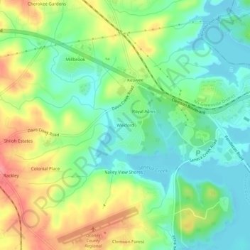
Name: Wexford topographic map, elevation, terrain.

Location: Wexford, Oconee County, South Carolina, 39678, United States (34.66816 -82.90042 34.70816 -82.86042)

Average elevation: 761 ft

Minimum elevation: 650 ft

Maximum elevation: 938 ft

Other topographic maps

Click on a map to view its topography, its elevation and its terrain.

Seneca

United States > South Carolina > Oconee County

Average elevation: 869 ft

Lake Keowee

United States > South Carolina > Oconee County > Seneca

Average elevation: 958 ft

Walhalla

United States > South Carolina > Oconee County

Average elevation: 971 ft

West Union

United States > South Carolina > Oconee County

Average elevation: 948 ft

Seneca

United States > South Carolina > Oconee County

Average elevation: 869 ft

Salem

United States > South Carolina > Oconee County

Average elevation: 1,037 ft

Westminster

United States > South Carolina > Oconee County

Average elevation: 892 ft

Seneca

United States > South Carolina > Oconee County

Average elevation: 869 ft

Salem

United States > South Carolina > Oconee County

Average elevation: 1,037 ft

Gear up for your next adventure:

📻Weather Alert Radios - Stay informed of storm risks while off-the-grid
Solar GPS Watches - Advanced multisport watches with built-in topographic maps
🧯Portable Fire Pit - Compact fire pit for camping spots
🪶Camp Gear Gift Set - Perfect gift bundle for outdoor fans
☀️Outdoor Sunscreen - High protection sunscreen for outdoor activities

As an Amazon Associate, this site earns from qualifying purchases at no extra cost to you.