Geolocate

Ollachea topographic map

Click on the map to display elevation.

About this map

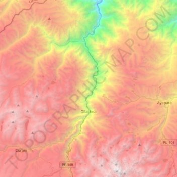
Name: Ollachea topographic map, elevation, terrain.

Location: Ollachea, Carabaya, Puno, Peru (-13.91510 -70.73587 -13.58577 -70.38801)

Average elevation: 12,582 ft

Minimum elevation: 3,599 ft

Maximum elevation: 19,006 ft

Other topographic maps

Click on a map to view its topography, its elevation and its terrain.

Puerto Leguia

Peru > Puno > Ayapata

Average elevation: 1,608 ft

Mazo Cruz

Peru > Puno

Average elevation: 13,071 ft

Trapiche

Peru > Puno > Ananea

Average elevation: 15,157 ft

Juliaca

Peru > Puno > Juliaca

Average elevation: 12,667 ft

La Rinconada

Peru > Puno

La Rinconada é uma cidade localizada nos Andes peruanos, próxima a uma mina de ouro. É considerada a cidade a maior altitude em todo o mundo, com um valor médio de 5100 m.

Average elevation: 16,152 ft

Macusani

Peru > Puno > Macusani

Average elevation: 14,790 ft

Juncal

Peru > Puno > San Antonio

Average elevation: 14,711 ft

Gear up for your next adventure:

🦶Carbon Trekking Poles - Reduce knee impact on steep descents with ultra-light poles
🔥Camping Stove - Portable stove for camping and backcountry cooking
📖Nature Tracking Books - Learn to track wildlife and terrain
🚁Photography Drones - Capture stunning aerial views of landforms and topography
📦Dry Bags Set - Waterproof storage for electronics and clothes

As an Amazon Associate, this site earns from qualifying purchases at no extra cost to you.