Geolocate

Porterville topographic map

Click on the map to display elevation.

About this map

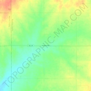
Name: Porterville topographic map, elevation, terrain.

Location: Porterville, Bourbon County, Kansas, United States (37.69810 -95.08886 37.73810 -95.04886)

Average elevation: 1,040 ft

Minimum elevation: 965 ft

Maximum elevation: 1,125 ft

Bourbon County trails, hiking, mountain biking, running and outdoor activities

Other topographic maps

Click on a map to view its topography, its elevation and its terrain.

Mapleton

United States > Kansas > Bourbon County

Average elevation: 876 ft

Redfield

United States > Kansas > Bourbon County

Average elevation: 863 ft

Fulton

United States > Kansas > Bourbon County

Average elevation: 827 ft

Bronson

United States > Kansas > Bourbon County

Average elevation: 1,060 ft

Gear up for your next adventure:

🛠️Backpacking Tool Kit - Essential toolkit for outdoor repairs
🪑Ultralight Camp Chairs - Portable seating for resting after a long day of mapping
🚪Portable Camp Chair - Foldable chair for comfort at camp
🧭Map Reading Tools - Tools and kits for map navigation
🦟Ultrasonic Repellers - Create a bug-free zone at your camp or rest stop

As an Amazon Associate, this site earns from qualifying purchases at no extra cost to you.