
Make a donation
Gear up for your next adventure:
As an Amazon Associate, this site earns from qualifying purchases at no extra cost to you.
Tuscumbia topographic map
Click on the map to display elevation.
Make a donation
Gear up for your next adventure:
As an Amazon Associate, this site earns from qualifying purchases at no extra cost to you.
About this map
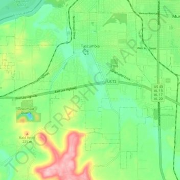
Name: Tuscumbia topographic map, elevation, terrain.
Location: Tuscumbia, Colbert County, Alabama, United States (34.67960 -87.75224 34.74554 -87.66029)
Average elevation: 522 ft
Minimum elevation: 328 ft
Maximum elevation: 886 ft
Colbert County trails, hiking, mountain biking, running and outdoor activities
Make a donation
Gear up for your next adventure:
As an Amazon Associate, this site earns from qualifying purchases at no extra cost to you.
Other topographic maps
Click on a map to view its topography, its elevation and its terrain.
Make a donation
Gear up for your next adventure:
As an Amazon Associate, this site earns from qualifying purchases at no extra cost to you.
River Oaks
United States > Alabama > Colbert County > Sheffield > River Oaks
Average elevation: 495 ft