
Tenmile topographic map
Click on the map to display elevation.
About this map
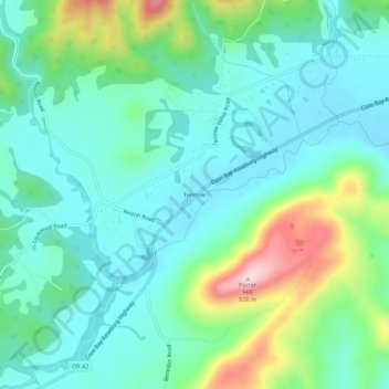
Name: Tenmile topographic map, elevation, terrain.
Location: Tenmile, Douglas County, Oregon, 97481, United States (43.07623 -123.58424 43.11623 -123.54424)
Average elevation: 915 ft
Minimum elevation: 653 ft
Maximum elevation: 1,703 ft
Douglas County trails, hiking, mountain biking, running and outdoor activities
Other topographic maps
Click on a map to view its topography, its elevation and its terrain.
Roseburg
United States > Oregon > Douglas County
Roseburg's elevation is approximately 500 feet (150 m). Its highest point is Mount Nebo, a 1,200-foot (370 m) hill to the west of Interstate 5. Through the 1980s, it was known for its band of 10-20 feral angora goats. Residents said they could predict the weather by watching where the goats were on the…
Average elevation: 784 ft
Elkton
United States > Oregon > Douglas County
According to the United States Census Bureau, the city has a total area of 0.26 square miles (0.67 km2), of which, 0.23 square miles (0.60 km2) is land and 0.03 square miles (0.08 km2) is water. The elevation is 141 feet (43 m).
Average elevation: 312 ft