
Make a donation
Gear up for your next adventure:
As an Amazon Associate, this site earns from qualifying purchases at no extra cost to you.
Mendenhall Springs topographic map
Click on the map to display elevation.
Make a donation
Gear up for your next adventure:
As an Amazon Associate, this site earns from qualifying purchases at no extra cost to you.
About this map
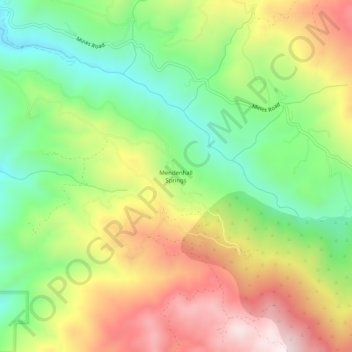
Name: Mendenhall Springs topographic map, elevation, terrain.
Average elevation: 1,998 ft
Minimum elevation: 991 ft
Maximum elevation: 3,261 ft
Alameda County trails, hiking, mountain biking, running and outdoor activities
Make a donation
Gear up for your next adventure:
As an Amazon Associate, this site earns from qualifying purchases at no extra cost to you.
Other topographic maps
Click on a map to view its topography, its elevation and its terrain.
Horseshoe Lake
United States > California > Alameda County > Fremont > Eberly
Average elevation: 75 ft
Quarry Lakes Regional Park
United States > California > Alameda County > Fremont > Eberly
Average elevation: 56 ft
Make a donation
Gear up for your next adventure:
As an Amazon Associate, this site earns from qualifying purchases at no extra cost to you.
Oakland Casting Club pools
United States > California > Alameda County > Oakland
Average elevation: 518 ft
Dougherty Hills Open Space
United States > California > Alameda County > Dublin > Komandorski Village
Average elevation: 394 ft
Make a donation
Gear up for your next adventure:
As an Amazon Associate, this site earns from qualifying purchases at no extra cost to you.
Reinhardt-Redwood Regional Park
United States > California > Alameda County > Oakland
Average elevation: 958 ft
Lake Del Valle
United States > California > Alameda County
The dam is 230 feet (70 m) high and 880 feet (270 m) long. Its crest elevation is 773 feet (236 m). The dam contains 4,150,000 cubic yards (3,170,000 m3) of earth fill.
Average elevation: 1,112 ft
Make a donation
Gear up for your next adventure:
As an Amazon Associate, this site earns from qualifying purchases at no extra cost to you.