Geolocate

Garrett topographic map

Click on the map to display elevation.

About this map

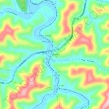
Name: Garrett topographic map, elevation, terrain.

Location: Garrett, Floyd County, Kentucky, 41630, United States (37.45982 -82.85155 37.49982 -82.81155)

Average elevation: 958 ft

Minimum elevation: 669 ft

Maximum elevation: 1,483 ft

Floyd County trails, hiking, mountain biking, running and outdoor activities

Other topographic maps

Click on a map to view its topography, its elevation and its terrain.

Wheelwright

United States > Kentucky > Floyd County

Average elevation: 1,460 ft

Allen

United States > Kentucky > Floyd County

Average elevation: 856 ft

Martin

United States > Kentucky > Floyd County

Average elevation: 883 ft

Gear up for your next adventure:

🧤Tactile Hiking Gloves - Keep hands warm while operating GPS and smartphone screens
🛡️Bear Spray Outdoor - Protection in bear country hikes
🥤Water Filter Bottle - All‑in‑one filter bottle for safe hydration
🩳Quick‑Dry Hiking Shorts - Comfortable and quick‑dry shorts for summer hiking
📡Handheld GPS Device - Reliable handheld GPS for outdoor navigation

As an Amazon Associate, this site earns from qualifying purchases at no extra cost to you.