
Samish Island topographic map
Click on the map to display elevation.
About this map
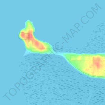
Name: Samish Island topographic map, elevation, terrain.
Location: Samish Island, Skagit County, Washington, United States (48.55594 -122.56100 48.59594 -122.52100)
Average elevation: 13 ft
Minimum elevation: -3 ft
Maximum elevation: 177 ft
Skagit County trails, hiking, mountain biking, running and outdoor activities
Other topographic maps
Click on a map to view its topography, its elevation and its terrain.
Skyline Home Owners Association
United States > Washington > Skagit County > Anacortes
Average elevation: 46 ft
Concrete
United States > Washington > Skagit County
Mears Field (3W5), formerly known as Concrete Municipal Airport, is located one mile south of Concrete at an elevation of 267 ft MSL.
Average elevation: 410 ft