
Make a donation
Gear up for your next adventure:
As an Amazon Associate, this site earns from qualifying purchases at no extra cost to you.
Auckland topographic map
Click on the map to display elevation.
Make a donation
Gear up for your next adventure:
As an Amazon Associate, this site earns from qualifying purchases at no extra cost to you.
Auckland
The Auckland Volcanic Field has contributed greatly to the growth and prosperity of the Auckland Region since the area was settled by humans. Initially, the maunga (scoria cones) were occupied and established as pā (fortified settlements) by Māori due to the strategic advantage their elevation provided in controlling resources and key portages between the Waitematā and Manukau harbours. The rich volcanic soils found in these areas also proved ideal for the cultivation of crops, such as kumara. Following European arrival, many of the maunga were transformed into quarries to supply the growing city with aggregate and building materials, and as a result were severely damaged or entirely destroyed. A number of the smaller maar craters and tuff rings were also removed during earthworks. Most of the remaining volcanic centres are now preserved within recreational reserves administered by Auckland Council, the Department of Conservation, and the Tūpuna Maunga o Tāmaki Makaurau Authority.
Make a donation
Gear up for your next adventure:
As an Amazon Associate, this site earns from qualifying purchases at no extra cost to you.
About this map
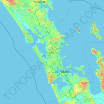
Name: Auckland topographic map, elevation, terrain.
Location: Auckland, New Zealand (-37.36447 173.89633 -35.69839 175.90322)
Average elevation: 98 ft
Minimum elevation: -3 ft
Maximum elevation: 2,743 ft
Make a donation
Gear up for your next adventure:
As an Amazon Associate, this site earns from qualifying purchases at no extra cost to you.
Other topographic maps
Click on a map to view its topography, its elevation and its terrain.
Make a donation
Gear up for your next adventure:
As an Amazon Associate, this site earns from qualifying purchases at no extra cost to you.
Port hills
New Zealand > Canterbury > Christchurch City > Linwood-Central-Heathcote Community
Average elevation: 807 ft
Make a donation
Gear up for your next adventure:
As an Amazon Associate, this site earns from qualifying purchases at no extra cost to you.
Cromwell
New Zealand > Otago > Central Otago District > Cromwell Community > Cromwell
Average elevation: 1,083 ft
Make a donation
Gear up for your next adventure:
As an Amazon Associate, this site earns from qualifying purchases at no extra cost to you.
Banks Peninsula
New Zealand > Canterbury > Christchurch City > Banks Peninsula Community > Pigeon Bay
Average elevation: 909 ft
Make a donation
Gear up for your next adventure:
As an Amazon Associate, this site earns from qualifying purchases at no extra cost to you.
Waihou Valley
New Zealand > Northland > Far North District > Kaikohe-Hokianga Community
Average elevation: 282 ft
Make a donation
Gear up for your next adventure:
As an Amazon Associate, this site earns from qualifying purchases at no extra cost to you.
Taumarunui
New Zealand > Manawatu-Whanganui > Ruapehu District
Under the Köppen, Taumarunui has an Oceanic climate:(Cfb). Due to location, low altitude and Geography surroundings, Taumarunui is more liable to warm to hot summers than other central North Island centres and in winter Taumarunui is cold and frosty. Rainfall yearly is 1,449 mm (57.047244 in). Annual sunshine…
Average elevation: 804 ft
Pungaere Stream
New Zealand > Northland > Far North District > Bay of Islands-Whangaroa Community
Average elevation: 600 ft
Make a donation
Gear up for your next adventure:
As an Amazon Associate, this site earns from qualifying purchases at no extra cost to you.
Ngāwī
New Zealand > Wellington > South Wairarapa District > Martinborough Community
Average elevation: 318 ft
Make a donation
Gear up for your next adventure:
As an Amazon Associate, this site earns from qualifying purchases at no extra cost to you.
Puwheke Beach
New Zealand > Northland > Far North District > Te Hiku Community
Average elevation: 16 ft
Make a donation
Gear up for your next adventure:
As an Amazon Associate, this site earns from qualifying purchases at no extra cost to you.
Pukawa
New Zealand > Northland > Far North District > Kaikohe-Hokianga Community
Average elevation: 331 ft
Make a donation
Gear up for your next adventure:
As an Amazon Associate, this site earns from qualifying purchases at no extra cost to you.
Make a donation
Gear up for your next adventure:
As an Amazon Associate, this site earns from qualifying purchases at no extra cost to you.
Hikuraki / North Mavora Lake
New Zealand > Southland > Southland District > Fiordland Community
Average elevation: 3,514 ft
Cass
New Zealand > Canterbury > Selwyn District
The topography of the Cass area was formed by repeated glaciation in the Pleistocene, with the valley floor built up by river fans as the glaciers retreated and the nearby Lakes Sarah and Grasmere enclosed by moraines and ice-eroded rocks. Many of the valleys around Cass post-date the retreat of the Poulter…
Average elevation: 2,188 ft
Make a donation
Gear up for your next adventure:
As an Amazon Associate, this site earns from qualifying purchases at no extra cost to you.
Fortrose
New Zealand > Southland > Southland District > Waihopai Toetoe Community
Average elevation: 39 ft
Make a donation
Gear up for your next adventure:
As an Amazon Associate, this site earns from qualifying purchases at no extra cost to you.
Ettrick
New Zealand > Otago > Central Otago District > Teviot Valley Community
Average elevation: 344 ft
Papamoa Hills Regional Park
New Zealand > Bay of Plenty > Western Bay of Plenty District
Average elevation: 174 ft
Make a donation
Gear up for your next adventure:
As an Amazon Associate, this site earns from qualifying purchases at no extra cost to you.
Tokanui
New Zealand > Southland > Southland District > Waihopai Toetoe Community
Average elevation: 279 ft
Make a donation
Gear up for your next adventure:
As an Amazon Associate, this site earns from qualifying purchases at no extra cost to you.
Make a donation
Gear up for your next adventure:
As an Amazon Associate, this site earns from qualifying purchases at no extra cost to you.
Broadwood
New Zealand > Northland > Far North District > Kaikohe-Hokianga Community
Average elevation: 472 ft
Make a donation
Gear up for your next adventure:
As an Amazon Associate, this site earns from qualifying purchases at no extra cost to you.
Waitākere Bay
New Zealand > Auckland > Waitakere Ranges > Te Henga / Bethells Beach
Average elevation: 59 ft
Make a donation
Gear up for your next adventure:
As an Amazon Associate, this site earns from qualifying purchases at no extra cost to you.
Whirinaki
New Zealand > Northland > Far North District > Kaikohe-Hokianga Community
Average elevation: 233 ft
Make a donation
Gear up for your next adventure:
As an Amazon Associate, this site earns from qualifying purchases at no extra cost to you.
Make a donation
Gear up for your next adventure:
As an Amazon Associate, this site earns from qualifying purchases at no extra cost to you.
Whangamarino
New Zealand > Bay of Plenty > Rotorua Lakes District > Okere Falls
Average elevation: 1,040 ft
Make a donation
Gear up for your next adventure:
As an Amazon Associate, this site earns from qualifying purchases at no extra cost to you.
Loburn
New Zealand > Canterbury > Waimakariri District
The Loburn-Ashley fault zone is located from the northern banks of the Ashley River through to about Hodgsons road in the north, it runs parallel to the Ashley river. The Loburn fault, which runs along the south side of Hodgsons Road, is responsible for various terraced abandoned stream channels, wedge…
Average elevation: 361 ft
Make a donation
Gear up for your next adventure:
As an Amazon Associate, this site earns from qualifying purchases at no extra cost to you.
Make a donation
Gear up for your next adventure:
As an Amazon Associate, this site earns from qualifying purchases at no extra cost to you.
Make a donation
Gear up for your next adventure:
As an Amazon Associate, this site earns from qualifying purchases at no extra cost to you.
Make a donation
Gear up for your next adventure:
As an Amazon Associate, this site earns from qualifying purchases at no extra cost to you.
Fern Hill
New Zealand > Northland > Far North District > Kaikohe-Hokianga Community
Average elevation: 400 ft
Make a donation
Gear up for your next adventure:
As an Amazon Associate, this site earns from qualifying purchases at no extra cost to you.