Geolocate

Forks topographic map

Click on the map to display elevation.

About this map

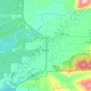
Name: Forks topographic map, elevation, terrain.

Location: Forks, Clallam County, Washington, United States (47.92930 -124.41973 47.97613 -124.35219)

Average elevation: 371 ft

Minimum elevation: 131 ft

Maximum elevation: 1,125 ft

Clallam County trails, hiking, mountain biking, running and outdoor activities

Other topographic maps

Click on a map to view its topography, its elevation and its terrain.

Ramapo

United States > Washington > Clallam County

Average elevation: 420 ft

La Push

United States > Washington > Clallam County

Average elevation: 56 ft

Beaver

United States > Washington > Clallam County

Average elevation: 604 ft

Elwha

United States > Washington > Clallam County

Average elevation: 912 ft

Maple Grove

United States > Washington > Clallam County

Average elevation: 1,263 ft

Elwha

United States > Washington > Clallam County

Average elevation: 912 ft

Agnew

United States > Washington > Clallam County

Average elevation: 177 ft

Hoko River

United States > Washington > Clallam County

Average elevation: 679 ft

Clallam Bay

United States > Washington > Clallam County

Average elevation: 128 ft

Lake Crescent

United States > Washington > Clallam County

Average elevation: 1,850 ft

Gear up for your next adventure:

🔊Portable Camp Speaker - Music and alerts at camp
🔋Solar Power Banks - Keep your GPS and phone charged in remote wilderness areas
🥾Women's Hiking Boots - Top-rated trail boots with ankle support and superior grip
🔭Stargazing Telescopes - Perfect for camping in low-light pollution areas shown on maps
💧Water Filtration Bottles - Safely drink from streams and lakes while exploring

As an Amazon Associate, this site earns from qualifying purchases at no extra cost to you.