
Make a donation
Gear up for your next adventure:
As an Amazon Associate, this site earns from qualifying purchases at no extra cost to you.
San Antonio topographic map
Click on the map to display elevation.
Make a donation
Gear up for your next adventure:
As an Amazon Associate, this site earns from qualifying purchases at no extra cost to you.
San Antonio
San Antonio features a diverse topography characterized by gently rolling hills and flat plains. The city's elevation averages around 650 feet above sea level, but nearby areas can reach heights of up to 1,300 feet in certain locations like Cross Mountain. The landscape is part of the southern edge of the Texas Hill Country, where limestone and clay dominate the soil composition, creating a unique terrain that includes valleys and ridges. The San Antonio River winds through the city, contributing to the area's hydrology and providing opportunities for recreational activities along the scenic River Walk. Overall, the region’s varied elevation and natural features make it a distinctive and attractive location within the broader Texas landscape.
Make a donation
Gear up for your next adventure:
As an Amazon Associate, this site earns from qualifying purchases at no extra cost to you.
About this map
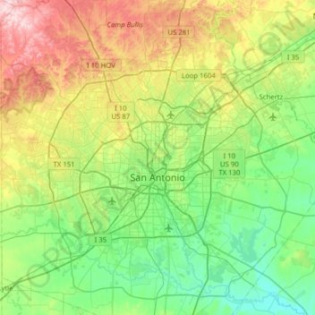
Name: San Antonio topographic map, elevation, terrain.
Location: San Antonio, Bexar County, Texas, United States (29.18626 -98.81319 29.73096 -98.22300)
Average elevation: 810 ft
Minimum elevation: 384 ft
Maximum elevation: 1,886 ft
Bexar County trails, hiking, mountain biking, running and outdoor activities
Make a donation
Gear up for your next adventure:
As an Amazon Associate, this site earns from qualifying purchases at no extra cost to you.
Other topographic maps
Click on a map to view its topography, its elevation and its terrain.
Make a donation
Gear up for your next adventure:
As an Amazon Associate, this site earns from qualifying purchases at no extra cost to you.
Medina River Natural Area
United States > Texas > Bexar County > San Antonio
Average elevation: 551 ft
Make a donation
Gear up for your next adventure:
As an Amazon Associate, this site earns from qualifying purchases at no extra cost to you.