Geolocate

Magog topographic map

Click on the map to display elevation.

About this map

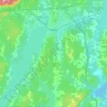
Name: Magog topographic map, elevation, terrain.

Location: Magog, Memphrémagog, Quebec, Canada (45.16080 -72.24729 45.30571 -72.04219)

Average elevation: 820 ft

Minimum elevation: 522 ft

Maximum elevation: 2,211 ft

Other topographic maps

Click on a map to view its topography, its elevation and its terrain.

Mont Orford

Canada > Quebec > Memphrémagog > Orford

Average elevation: 1,834 ft

Mont Owl's Head

Canada > Quebec > Memphrémagog > Potton

Average elevation: 1,214 ft

Club-Hermitage

Canada > Quebec > Memphrémagog > Magog

Average elevation: 735 ft

Mont Boisjoli

Canada > Quebec > Memphrémagog > Hatley (Canton)

Average elevation: 876 ft

Georgeville

Canada > Quebec > Memphrémagog > Stanstead (Canton)

Average elevation: 778 ft

Mansonville

Canada > Quebec > Memphrémagog > Potton

Average elevation: 692 ft

Vale Perkins

Canada > Quebec > Memphrémagog > Potton

Average elevation: 942 ft

Gear up for your next adventure:

🦟Ultrasonic Repellers - Create a bug-free zone at your camp or rest stop
🪶LED Camping Lantern - Bright lantern for camp lighting
🔦LED Headlamp - Bright and durable LED headlamp for night navigation
📖Nature Tracking Books - Learn to track wildlife and terrain
😴Insulated Sleeping Pads - Compact and warm pads for high-elevation camping

As an Amazon Associate, this site earns from qualifying purchases at no extra cost to you.