Geolocate

Honaker topographic map

Click on the map to display elevation.

About this map

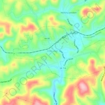
Name: Honaker topographic map, elevation, terrain.

Location: Honaker, Russell County, Virginia, 24260, United States (37.00700 -81.99047 37.02441 -81.94690)

Average elevation: 2,034 ft

Minimum elevation: 1,785 ft

Maximum elevation: 2,425 ft

Russell County trails, hiking, mountain biking, running and outdoor activities

Other topographic maps

Click on a map to view its topography, its elevation and its terrain.

Russell

United States > Virginia > Russell County

Average elevation: 2,513 ft

Putnam

United States > Virginia > Russell County > Honaker

Average elevation: 2,067 ft

Sun

United States > Virginia > Russell County

Average elevation: 1,926 ft

Hamlin

United States > Virginia > Russell County

Average elevation: 1,831 ft

Lebanon

United States > Virginia > Russell County > Lebanon

Average elevation: 2,234 ft

Gear up for your next adventure:

📷Action Camera - Capture your outdoor adventures in HD
🏕️Tent Footprint - Protect your tent base from wear
🥾Women's Hiking Boots - Top-rated trail boots with ankle support and superior grip
🚗GPS Dash Cams - Record your scenic drives through mountain passes and canyons
🏫Relief Map Kits - Hands-on tools for teaching landforms and elevation

As an Amazon Associate, this site earns from qualifying purchases at no extra cost to you.