Geolocate

Elba topographic map

Click on the map to display elevation.

About this map

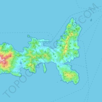
Name: Elba topographic map, elevation, terrain.

Location: Elba, Livorno, Tuscany, Italy (42.70750 10.10250 42.87295 10.44414)

Average elevation: 112 ft

Minimum elevation: -3 ft

Maximum elevation: 3,035 ft

Other topographic maps

Click on a map to view its topography, its elevation and its terrain.

Bolgheri

Italy > Tuscany > Livorno > Castagneto Carducci

Average elevation: 361 ft

Casetta di Cornia

Italy > Tuscany > Livorno > Suvereto

Average elevation: 82 ft

Sant'Ilario

Italy > Tuscany > Livorno

Average elevation: 728 ft

Namia

Italy > Tuscany > Livorno > Porto Azzurro

Average elevation: 436 ft

Populonia

Italy > Tuscany > Livorno > Piombino

In geology, the "Tuscan metallogenic province" derived from volcanic intrusions into southern Etruria due to extension of the crust there (which also created a karst topography in western Italy) from the late Miocene to the Pleistocene. This process emplaced iron oxide deposits on Elba, pyrite in southern…

Average elevation: 112 ft

Bolgheri

Italy > Tuscany > Livorno > Castagneto Carducci

Average elevation: 361 ft

Monte Orello

Italy > Tuscany > Livorno > Capoliveri

Average elevation: 482 ft

Fornaci

Italy > Tuscany > Livorno > Sassetta

Average elevation: 1,063 ft

Gear up for your next adventure:

🏥Hiking First Aid Kits - Comprehensive medical kits for remote trail injuries
🛏️Cold Weather Sleeping Bag - Warm sleeping bag for cold conditions
🏕️Tent Footprint - Protect your tent base from wear
🛡️Bear Spray Outdoor - Protection in bear country hikes
🧭Compass with Lanyard - Easy‑carry compass for navigation

As an Amazon Associate, this site earns from qualifying purchases at no extra cost to you.