Geolocate

Spanish Fork topographic map

Click on the map to display elevation.

About this map

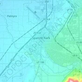
Name: Spanish Fork topographic map, elevation, terrain.

Location: Spanish Fork, Utah County, Utah, 84660, United States (40.06423 -111.69396 40.17318 -111.57470)

Average elevation: 4,610 ft

Minimum elevation: 4,478 ft

Maximum elevation: 6,542 ft

Utah County trails, hiking, mountain biking, running and outdoor activities

Other topographic maps

Click on a map to view its topography, its elevation and its terrain.

Spanish Fork Peak

United States > Utah > Utah County

Average elevation: 8,924 ft

Mount Timpanogos

United States > Utah > Utah County

Average elevation: 10,299 ft

Bald Mountain Overlook

United States > Utah > Utah County

Average elevation: 8,373 ft

Lone Peak

United States > Utah > Utah County

Average elevation: 9,885 ft

Curtis

United States > Utah > Utah County > Orem

Average elevation: 4,701 ft

Birdseye

United States > Utah > Utah County

Average elevation: 5,840 ft

Nutty Putty Cave

United States > Utah > Utah County

Average elevation: 5,075 ft

Mount Timpanogos

United States > Utah > Utah County

Average elevation: 10,299 ft

Caryhurst

United States > Utah > Utah County > Provo

Average elevation: 5,128 ft

Pleasant View

United States > Utah > Utah County > Provo

Average elevation: 4,744 ft

Townsend

United States > Utah > Utah County > Genola

Average elevation: 4,718 ft

Lone Peak

United States > Utah > Utah County

Average elevation: 9,885 ft

Gear up for your next adventure:

🪑Portable Camp Table - Compact table for campsite meals
GPS Sports Watch - GPS watch for running, hiking and training
🥾Hiking Shoes - Durable and comfortable shoes for trail hiking
🧭Orienteering Set - Complete compass and map reading kit
🧣Hiking Neck Gaiter - Multi‑use neck protection for outdoor weather

As an Amazon Associate, this site earns from qualifying purchases at no extra cost to you.