
Make a donation
Gear up for your next adventure:
As an Amazon Associate, this site earns from qualifying purchases at no extra cost to you.
Rimini topographic map
Click on the map to display elevation.
Make a donation
Gear up for your next adventure:
As an Amazon Associate, this site earns from qualifying purchases at no extra cost to you.
Rimini
To its southwest, Rimini is surrounded by several rolling hills: Covignano (153 metres (502 feet) altitude), Vergiano (81 metres (266 feet) altitude), San Martino Monte l'Abbate (57 metres (187 feet) altitude) and San Lorenzo in Correggiano (60 metres (200 feet) altitude). The hills are widely cultivated, with vineyards, olive groves and orchards, and historic villas.
Make a donation
Gear up for your next adventure:
As an Amazon Associate, this site earns from qualifying purchases at no extra cost to you.
About this map
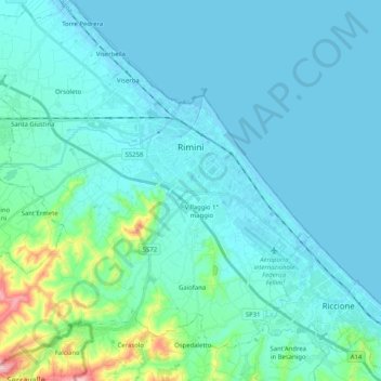
Name: Rimini topographic map, elevation, terrain.
Location: Rimini, Emilia-Romagna, 47921-47924, Italy (43.96968 12.43849 44.11579 12.63289)
Average elevation: 85 ft
Minimum elevation: -10 ft
Maximum elevation: 692 ft
Make a donation
Gear up for your next adventure:
As an Amazon Associate, this site earns from qualifying purchases at no extra cost to you.
Other topographic maps
Click on a map to view its topography, its elevation and its terrain.
Make a donation
Gear up for your next adventure:
As an Amazon Associate, this site earns from qualifying purchases at no extra cost to you.