
Make a donation
Gear up for your next adventure:
As an Amazon Associate, this site earns from qualifying purchases at no extra cost to you.
Maciano topographic map
Click on the map to display elevation.
Make a donation
Gear up for your next adventure:
As an Amazon Associate, this site earns from qualifying purchases at no extra cost to you.
About this map
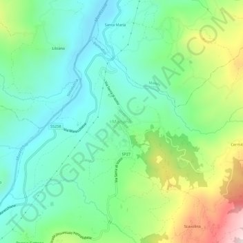
Name: Maciano topographic map, elevation, terrain.
Average elevation: 1,558 ft
Minimum elevation: 928 ft
Maximum elevation: 3,031 ft
Make a donation
Gear up for your next adventure:
As an Amazon Associate, this site earns from qualifying purchases at no extra cost to you.
Other topographic maps
Click on a map to view its topography, its elevation and its terrain.
Riccione
Italy > Emilia-Romagna > Rimini
Riccione's principal hill, to its south, is known as Cavrèt d'Arvura. Riccione's maximum elevation is 75 metres (246 feet) above sea level, with a mean elevation of 15.2 metres (50 feet).
Average elevation: 46 ft
Rimini
Italy > Emilia-Romagna > Rimini
To its southwest, Rimini is surrounded by several rolling hills: Covignano (153 metres (502 feet) altitude), Vergiano (81 metres (266 feet) altitude), San Martino Monte l'Abbate (57 metres (187 feet) altitude) and San Lorenzo in Correggiano (60 metres (200 feet) altitude). The hills are widely cultivated, with…
Average elevation: 85 ft
Riccione
Italy > Emilia-Romagna > Rimini
Riccione's principal hill, to its south, is known as Cavrèt d'Arvura. Riccione's maximum elevation is 75 metres (246 feet) above sea level, with a mean elevation of 15.2 metres (50 feet).
Average elevation: 46 ft
Make a donation
Gear up for your next adventure:
As an Amazon Associate, this site earns from qualifying purchases at no extra cost to you.