
Perticara topographic map
Click on the map to display elevation.
About this map
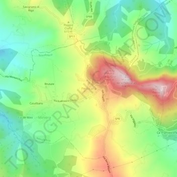
Name: Perticara topographic map, elevation, terrain.
Average elevation: 1,775 ft
Minimum elevation: 1,083 ft
Maximum elevation: 2,808 ft
Other topographic maps
Click on a map to view its topography, its elevation and its terrain.
Rimini
Italy > Emilia-Romagna > Rimini
To its southwest, Rimini is surrounded by several rolling hills: Covignano (153 metres (502 feet) altitude), Vergiano (81 metres (266 feet) altitude), San Martino Monte l'Abbate (57 metres (187 feet) altitude) and San Lorenzo in Correggiano (60 metres (200 feet) altitude). The hills are widely cultivated, with…
Average elevation: 85 ft
Riccione
Italy > Emilia-Romagna > Rimini
Riccione's principal hill, to its south, is known as Cavrèt d'Arvura. Riccione's maximum elevation is 75 metres (246 feet) above sea level, with a mean elevation of 15.2 metres (50 feet).
Average elevation: 46 ft
Riccione
Italy > Emilia-Romagna > Rimini
Riccione's principal hill, to its south, is known as Cavrèt d'Arvura. Riccione's maximum elevation is 75 metres (246 feet) above sea level, with a mean elevation of 15.2 metres (50 feet).
Average elevation: 46 ft