Geolocate

Madison topographic map

Click on the map to display elevation.

About this map

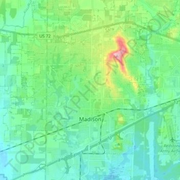
Name: Madison topographic map, elevation, terrain.

Location: Madison, Madison County, Alabama, United States (34.66262 -86.85102 34.76163 -86.70606)

Average elevation: 689 ft

Minimum elevation: 561 ft

Maximum elevation: 1,148 ft

Madison County trails, hiking, mountain biking, running and outdoor activities

Other topographic maps

Click on a map to view its topography, its elevation and its terrain.

Bucks Canyon

United States > Alabama > Madison County > Huntsville

Average elevation: 837 ft

Brownsboro

United States > Alabama > Madison County

Average elevation: 666 ft

Russell Hill

United States > Alabama > Madison County > Huntsville

Average elevation: 666 ft

Regent Forest

United States > Alabama > Madison County > Huntsville

Average elevation: 636 ft

Normal

United States > Alabama > Madison County > Huntsville

Average elevation: 774 ft

Eastridge

United States > Alabama > Madison County > Huntsville

Average elevation: 853 ft

Redstone Park

United States > Alabama > Madison County > Huntsville

Average elevation: 604 ft

Madison Point

United States > Alabama > Madison County > Madison

Average elevation: 696 ft

Hawks Ridge

United States > Alabama > Madison County > Huntsville

Average elevation: 919 ft

Walker Woods

United States > Alabama > Madison County > Huntsville

Average elevation: 945 ft

Camelot

United States > Alabama > Madison County > Huntsville

Average elevation: 883 ft

Toney

United States > Alabama > Madison County

Average elevation: 837 ft

Camelot

United States > Alabama > Madison County > Huntsville

Average elevation: 883 ft

Gurley

United States > Alabama > Madison County

Average elevation: 768 ft

Oak Park

United States > Alabama > Madison County > Huntsville

Average elevation: 922 ft

Gear up for your next adventure:

🪵Folding Camp Saw - Compact saw for wood and campsite work
🚗GPS Dash Cams - Record your scenic drives through mountain passes and canyons
🌡️Handheld Weather Meters - Measure wind, temp, and pressure for safe mountain travel
🧭Pro Hiking Compasses - High-accuracy liquid-filled compasses for topographic orientation
📷Action Cameras - Rugged cameras to document your journeys across rugged terrain

As an Amazon Associate, this site earns from qualifying purchases at no extra cost to you.