
Biebergemünd topographic map
Interactive map
Click on the map to display elevation.
About this map
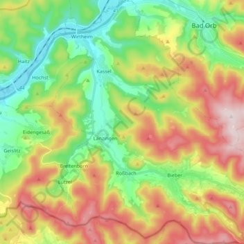
Name: Biebergemünd topographic map, elevation, terrain.
Location: Biebergemünd, Main-Kinzig-Kreis, Hesse, 63599, Germany (50.13052 9.24254 50.23867 9.40521)
Average elevation: 978 ft
Minimum elevation: 420 ft
Maximum elevation: 1,772 ft
Biebergemünd is mostly located in the Hessian part of the Spessart at elevations between 140 and 250 metres above NHN. Around 70% of the municipal territory is covered by forest. In the north, the municipality extends into the valley of the Kinzig river.
Other topographic maps
Click on a map to view its topography, its elevation and its terrain.
Oberzell
Germany > Hesse > Main-Kinzig-Kreis
Oberzell, Sinntal, Main-Kinzig-Kreis, Hesse, Germany
Average elevation: 1,486 ft
Wächtersbach
Germany > Hesse > Main-Kinzig-Kreis
Wächtersbach, Main-Kinzig-Kreis, Hesse, 63607, Germany
Average elevation: 774 ft
Hochstadt
Germany > Hesse > Main-Kinzig-Kreis
Hochstadt, Maintal, Main-Kinzig-Kreis, Hesse, 63477, Germany
Average elevation: 446 ft
Maintal
Germany > Hesse > Main-Kinzig-Kreis
Maintal, Main-Kinzig-Kreis, Hesse, 63477, Germany
Average elevation: 410 ft
Hanau
Germany > Hesse > Main-Kinzig-Kreis
Hanau, Main-Kinzig-Kreis, Hesse, Germany
Average elevation: 384 ft
Steinau an der Straße
Germany > Hesse > Main-Kinzig-Kreis
Steinau an der Straße, Main-Kinzig-Kreis, Hesse, 36396, Germany
Average elevation: 1,102 ft