
Steinau an der Straße topographic map
Interactive map
Click on the map to display elevation.
About this map
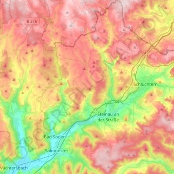
Name: Steinau an der Straße topographic map, elevation, terrain.
Location: Steinau an der Straße, Main-Kinzig-Kreis, Hesse, 36396, Germany (50.24718 9.36389 50.44255 9.55906)
Average elevation: 1,102 ft
Minimum elevation: 453 ft
Maximum elevation: 1,706 ft
Steinau is located at an elevation of around 175 m above NHN in the valley of the Kinzig river which divides the hills of the Spessart (to the south) from the Vogelsberg (to the north). The municipal territory extends into both ranges.
Other topographic maps
Click on a map to view its topography, its elevation and its terrain.
Oberzell
Germany > Hesse > Main-Kinzig-Kreis
Oberzell, Sinntal, Main-Kinzig-Kreis, Hesse, Germany
Average elevation: 1,486 ft
Wächtersbach
Germany > Hesse > Main-Kinzig-Kreis
Wächtersbach, Main-Kinzig-Kreis, Hesse, 63607, Germany
Average elevation: 774 ft
Hochstadt
Germany > Hesse > Main-Kinzig-Kreis
Hochstadt, Maintal, Main-Kinzig-Kreis, Hesse, 63477, Germany
Average elevation: 446 ft
Maintal
Germany > Hesse > Main-Kinzig-Kreis
Maintal, Main-Kinzig-Kreis, Hesse, 63477, Germany
Average elevation: 410 ft
Hanau
Germany > Hesse > Main-Kinzig-Kreis
Hanau, Main-Kinzig-Kreis, Hesse, Germany
Average elevation: 384 ft
Biebergemünd
Germany > Hesse > Main-Kinzig-Kreis
Biebergemünd, Main-Kinzig-Kreis, Hesse, 63599, Germany
Average elevation: 978 ft