Geolocate

Agnes topographic map

Interactive map

Click on the map to display elevation.

About this map

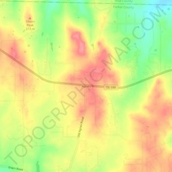
Name: Agnes topographic map, elevation, terrain.

Location: Agnes, Parker County, Texas, 76482, United States (32.95929 -97.80864 32.99929 -97.76864)

Average elevation: 1,152 ft

Minimum elevation: 994 ft

Maximum elevation: 1,263 ft

Parker County trails, hiking, mountain biking, running and outdoor activities

Other topographic maps

Click on a map to view its topography, its elevation and its terrain.

Weatherford

United States > Texas > Parker County

Average elevation: 1,070 ft

Sanctuary

United States > Texas > Parker County

Average elevation: 781 ft

Hudson Oaks

United States > Texas > Parker County

Average elevation: 978 ft

Springtown

United States > Texas > Parker County

Average elevation: 896 ft

Cool

United States > Texas > Parker County

Average elevation: 932 ft

Weatherford

United States > Texas > Parker County

Average elevation: 1,089 ft