
Make a donation
Gear up for your next adventure:
As an Amazon Associate, this site earns from qualifying purchases at no extra cost to you.
Medicine Park topographic map
Click on the map to display elevation.
Make a donation
Gear up for your next adventure:
As an Amazon Associate, this site earns from qualifying purchases at no extra cost to you.
About this map
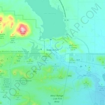
Name: Medicine Park topographic map, elevation, terrain.
Average elevation: 1,407 ft
Minimum elevation: 1,191 ft
Maximum elevation: 2,470 ft
Comanche County trails, hiking, mountain biking, running and outdoor activities
Make a donation
Gear up for your next adventure:
As an Amazon Associate, this site earns from qualifying purchases at no extra cost to you.
Other topographic maps
Click on a map to view its topography, its elevation and its terrain.
Wichita Mountains Wildlife Refuge
United States > Oklahoma > Comanche County
Average elevation: 1,942 ft
Medicine Bluffs
United States > Oklahoma > Comanche County > Lawton > White Wolf Bridge
Average elevation: 1,191 ft
Make a donation
Gear up for your next adventure:
As an Amazon Associate, this site earns from qualifying purchases at no extra cost to you.
Make a donation
Gear up for your next adventure:
As an Amazon Associate, this site earns from qualifying purchases at no extra cost to you.
South East Corner Landing Strip
United States > Oklahoma > Comanche County
Average elevation: 1,257 ft