Geolocate

Wanette topographic map

Click on the map to display elevation.

About this map

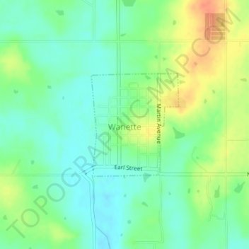
Name: Wanette topographic map, elevation, terrain.

Location: Wanette, Pottawatomie County, Oklahoma, United States (34.95666 -97.03695 34.96781 -97.02535)

Average elevation: 1,014 ft

Minimum elevation: 958 ft

Maximum elevation: 1,106 ft

Pottawatomie County trails, hiking, mountain biking, running and outdoor activities

Other topographic maps

Click on a map to view its topography, its elevation and its terrain.

Trousdale

United States > Oklahoma > Pottawatomie County

Average elevation: 997 ft

Macomb

United States > Oklahoma > Pottawatomie County > Macomb

Average elevation: 978 ft

Centerview

United States > Oklahoma > Pottawatomie County

Average elevation: 961 ft

Harjo

United States > Oklahoma > Pottawatomie County

Average elevation: 932 ft

Gear up for your next adventure:

🧣Merino Neck Gaiters - Multi-functional headwear for wind and sun protection
📚Navigation Handbooks - Master the art of reading topographic maps and using a compass
🦟Ultrasonic Repellers - Create a bug-free zone at your camp or rest stop
🥾Hiking Shoes - Durable and comfortable shoes for trail hiking
🧼Biodegradable Camping Soap - Eco‑friendly soap for outdoor hygiene

As an Amazon Associate, this site earns from qualifying purchases at no extra cost to you.