
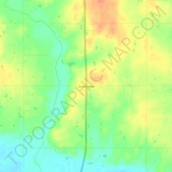
Centerview topographic map
Click on the map to display elevation.
About this map
Name: Centerview topographic map, elevation, terrain.
Location: Centerview, Pottawatomie County, Oklahoma, United States (35.41368 -96.68529 35.45368 -96.64529)
Average elevation: 961 ft
Minimum elevation: 889 ft
Maximum elevation: 1,030 ft
Pottawatomie County trails, hiking, mountain biking, running and outdoor activities
Other topographic maps
Click on a map to view its topography, its elevation and its terrain.
Pink
United States > Oklahoma > Pottawatomie County
The 1891 Oklahoma and Indian Territories map portrays Shawneetown (Shawnee) as the only settlement north of Little River in the future Pottawatomie County. Pink appears later on Cram's 1898 Oklahoma and Indian Territory Map.] Topographic mapping of Pink and Pottawatomie County began sometime after 1903. Pink…
Average elevation: 1,063 ft