Geolocate

Aralam topographic map

Click on the map to display elevation.

About this map

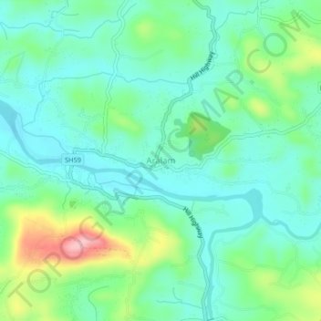
Name: Aralam topographic map, elevation, terrain.

Location: Aralam, Iritty, Kannur District, Kerala, 670704, India (11.94103 75.70644 11.98103 75.74644)

Average elevation: 220 ft

Minimum elevation: 79 ft

Maximum elevation: 610 ft

Other topographic maps

Click on a map to view its topography, its elevation and its terrain.

Ulikkal

India > Kerala > Iritty > Nuchiyad

Average elevation: 528 ft

Iritty

India > Kerala > Iritty

Average elevation: 213 ft

Kottiyoor

India > Kerala > Iritty > Ambayathode

Average elevation: 1,293 ft

Aralam

India > Kerala > Iritty > Iritty

Average elevation: 282 ft

Kelakam

India > Kerala > Iritty > Adakkathodu

Average elevation: 1,063 ft

Aralam WLS

India > Kerala > Iritty > Adakkathodu

Average elevation: 1,516 ft

Gear up for your next adventure:

🛠️Outdoor Gear Repair Kit - Essential tools to fix gear on the trail
🌎3D Topographic Globes - Raised relief globes for a tactile understanding of geography
🦶Carbon Trekking Poles - Reduce knee impact on steep descents with ultra-light poles
🔥Camping Stove - Portable stove for camping and backcountry cooking
🧭Orienteering Set - Complete compass and map reading kit

As an Amazon Associate, this site earns from qualifying purchases at no extra cost to you.