Geolocate

Ringerike topographic map

Click on the map to display elevation.

About this map

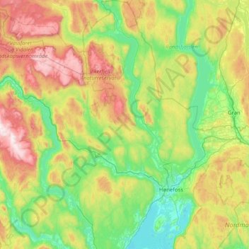
Name: Ringerike topographic map, elevation, terrain.

Location: Ringerike, Viken, Norway (60.01726 9.70451 60.63793 10.60154)

Average elevation: 1,453 ft

Minimum elevation: 180 ft

Maximum elevation: 4,754 ft

Other topographic maps

Click on a map to view its topography, its elevation and its terrain.

Ribba

Norway > Viken

Average elevation: 16 ft

Land

Norway > Viken

Average elevation: 709 ft

Sandvika

Norway > Viken

Average elevation: 197 ft

Engelsviken

Norway > Viken > Engelsviken

Average elevation: 39 ft

Gear up for your next adventure:

📡Handheld GPS Device - Reliable handheld GPS for outdoor navigation
📶Vehicle Signal Boosters - Improve reception in rural areas while driving to trailheads
🥤Water Filter Bottle - All‑in‑one filter bottle for safe hydration
🚪Portable Camp Chair - Foldable chair for comfort at camp
☀️Outdoor Sunscreen - High protection sunscreen for outdoor activities

As an Amazon Associate, this site earns from qualifying purchases at no extra cost to you.