
Kohala küla topographic map
Interactive map
Click on the map to display elevation.
About this map
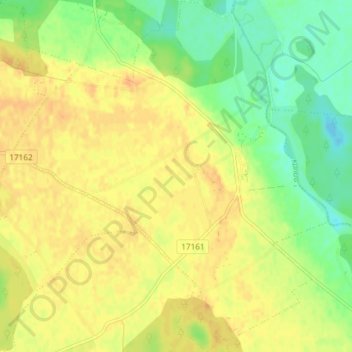
Name: Kohala küla topographic map, elevation, terrain.
Location: Kohala küla, Rakvere vald, West-Wierland, Estland (59.39417 26.48335 59.43175 26.54977)
Average elevation: 207 ft
Minimum elevation: 148 ft
Maximum elevation: 246 ft
Other topographic maps
Click on a map to view its topography, its elevation and its terrain.
Tallinn
Tallinn, Stadtgemeinde Reval, Kreis Harrien, Estland
Average elevation: 52 ft
Püssi linn
Püssi linn, Lüganuse vald, Kreis Ost-Wierland, Estland
Average elevation: 144 ft
Lääne-Harju vald
Lääne-Harju vald, Kreis Harrien, Estland
Average elevation: 75 ft
Lõunaküla / Storbyn
Lõunaküla / Storbyn, Viimsi vald, Kreis Harrien, 74022, Estland
Average elevation: 39 ft
Kriilevälja küla
Kriilevälja küla, Kriilevälja, Paide linn, Kreis Jerwen, Estland
Average elevation: 210 ft
Vilama küla
Vilama küla, Vilama, Kose vald, Harju maakond, Estland
Average elevation: 226 ft