Geolocate

Washington topographic map

Click on the map to display elevation.

About this map

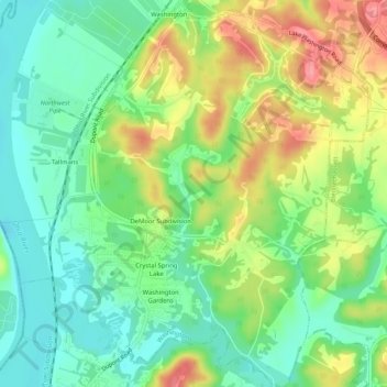
Name: Washington topographic map, elevation, terrain.

Location: Washington, Wood County, West Virginia, United States (39.22258 -81.69163 39.26259 -81.64496)

Average elevation: 682 ft

Minimum elevation: 561 ft

Maximum elevation: 873 ft

Wood County trails, hiking, mountain biking, running and outdoor activities

Other topographic maps

Click on a map to view its topography, its elevation and its terrain.

Deerwalk

United States > West Virginia > Wood County

Average elevation: 925 ft

Belleville

United States > West Virginia > Wood County

Average elevation: 679 ft

Lee Creek

United States > West Virginia > Wood County

Average elevation: 673 ft

Slate

United States > West Virginia > Wood County

Average elevation: 738 ft

Ogden

United States > West Virginia > Wood County

Average elevation: 817 ft

Gear up for your next adventure:

🏕️Family Camping Gear - Essentials for group camping trips
🗻Climbing Gear Basics - Essential gear for beginner climbers
🪑Portable Camp Table - Compact table for campsite meals
🦶Carbon Trekking Poles - Reduce knee impact on steep descents with ultra-light poles
🥩Freeze-Dried Meals - Nutritious and lightweight food for remote expeditions

As an Amazon Associate, this site earns from qualifying purchases at no extra cost to you.