
Make a donation
Gear up for your next adventure:
As an Amazon Associate, this site earns from qualifying purchases at no extra cost to you.
Niassa Province topographic map
Click on the map to display elevation.
Make a donation
Gear up for your next adventure:
As an Amazon Associate, this site earns from qualifying purchases at no extra cost to you.
About this map
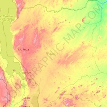
Name: Niassa Province topographic map, elevation, terrain.
Location: Niassa Province, Mozambique (-15.48022 34.37823 -11.25869 38.48690)
Average elevation: 2,087 ft
Minimum elevation: 443 ft
Maximum elevation: 7,418 ft
Make a donation
Gear up for your next adventure:
As an Amazon Associate, this site earns from qualifying purchases at no extra cost to you.
Other topographic maps
Click on a map to view its topography, its elevation and its terrain.
Xai-Xai
At an elevation of 9.8 m (32 ft), Xai-Xai is located on the Limpopo River, close to the Indian Ocean, and in a wide, fertile plain where rice is grown. It is 200 kilometres (120 mi) from the capital, Maputo, and is 5.2 km (3+1⁄4 mi) from Donguene, 4.0 km (2+1⁄2 mi) from Macandene, 2.8 km (1+3⁄4 mi) from…
Average elevation: 62 ft
Lichinga
Lichinga is the capital city of Niassa Province of Mozambique. It lies on the Lichinga Plateau at an altitude of 1,360 metres (4,460 ft), east of Lake Niassa (Lake Malawi). The town was founded as Vila Cabral as a farming and military settlement. It is served by Lichinga Airport. The province borders Ruvuma…
Average elevation: 3,825 ft
Make a donation
Gear up for your next adventure:
As an Amazon Associate, this site earns from qualifying purchases at no extra cost to you.
Make a donation
Gear up for your next adventure:
As an Amazon Associate, this site earns from qualifying purchases at no extra cost to you.
Make a donation
Gear up for your next adventure:
As an Amazon Associate, this site earns from qualifying purchases at no extra cost to you.