Geolocate

Blue River topographic map

Click on the map to display elevation.

About this map

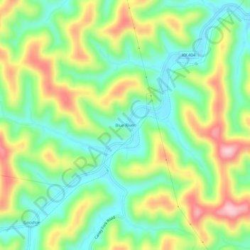
Name: Blue River topographic map, elevation, terrain.

Location: Blue River, Floyd County, Kentucky, 41607, United States (37.59926 -82.86377 37.63926 -82.82377)

Average elevation: 909 ft

Minimum elevation: 620 ft

Maximum elevation: 1,358 ft

Floyd County trails, hiking, mountain biking, running and outdoor activities

Other topographic maps

Click on a map to view its topography, its elevation and its terrain.

Wheelwright

United States > Kentucky > Floyd County

Average elevation: 1,460 ft

Allen

United States > Kentucky > Floyd County

Average elevation: 856 ft

Martin

United States > Kentucky > Floyd County

Average elevation: 883 ft

Gear up for your next adventure:

🧣Merino Neck Gaiters - Multi-functional headwear for wind and sun protection
🧤Hiking Gloves - Protective gloves for rugged trails
🪶Camp Gear Gift Set - Perfect gift bundle for outdoor fans
🛡️Bear Spray Outdoor - Protection in bear country hikes
🪶Trail Camera - Capture wildlife on your hikes

As an Amazon Associate, this site earns from qualifying purchases at no extra cost to you.