
Mogul topographic map
Click on the map to display elevation.
About this map
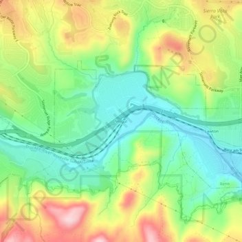
Name: Mogul topographic map, elevation, terrain.
Location: Mogul, Washoe County, Nevada, 89523, United States (39.49380 -119.94603 39.53380 -119.90603)
Average elevation: 4,977 ft
Minimum elevation: 4,639 ft
Maximum elevation: 5,486 ft
Washoe County trails, hiking, mountain biking, running and outdoor activities
Other topographic maps
Click on a map to view its topography, its elevation and its terrain.
Sand Harbor
United States > Nevada > Washoe County > Incline Village-Crystal Bay
Average elevation: 6,581 ft