
Bush topographic map
Click on the map to display elevation.
About this map
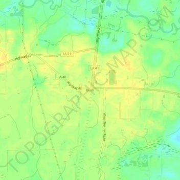
Name: Bush topographic map, elevation, terrain.
Location: Bush, St. Tammany Parish, Louisiana, United States (30.58880 -89.92007 30.62880 -89.88007)
Average elevation: 72 ft
Minimum elevation: 26 ft
Maximum elevation: 102 ft
St. Tammany Parish trails, hiking, mountain biking, running and outdoor activities
Other topographic maps
Click on a map to view its topography, its elevation and its terrain.
Mandeville
United States > Louisiana > St. Tammany Parish
Mandeville is located at 30°22′9″N 90°4′41″W / 30.36917°N 90.07806°W / 30.36917; -90.07806 (30.369282, -90.078006), and has an elevation of 7 feet (2.1 m). According to the United States Census Bureau, the city has a total area of 6.8 square miles (17.7 km2), of which 0.12 square miles…
Average elevation: 20 ft
Slidell
United States > Louisiana > St. Tammany Parish
Slidell is located at 30°16′45″N 89°46′40″W / 30.27917°N 89.77778°W / 30.27917; -89.77778 (30.279040, -89.777744), and has an elevation of 13 feet (4.0 m). It is in southeastern St. Tammany Parish, located approximately 3 miles (5 km) north of Lake Pontchartrain. The city forms part of the…
Average elevation: 20 ft