Geolocate

Viola topographic map

Click on the map to display elevation.

About this map

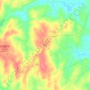
Name: Viola topographic map, elevation, terrain.

Location: Viola, Heard County, Georgia, United States (33.23484 -85.16883 33.27484 -85.12883)

Average elevation: 778 ft

Minimum elevation: 640 ft

Maximum elevation: 912 ft

Heard County trails, hiking, mountain biking, running and outdoor activities

Other topographic maps

Click on a map to view its topography, its elevation and its terrain.

Corinth

United States > Georgia > Heard County

Average elevation: 764 ft

Centralhatchee

United States > Georgia > Heard County

Average elevation: 827 ft

Ephesus

United States > Georgia > Heard County

Average elevation: 1,181 ft

Franklin

United States > Georgia > Heard County

Average elevation: 732 ft

Gear up for your next adventure:

📦Dry Bags Set - Waterproof storage for electronics and clothes
🧥Men's Rain Shells - Premium waterproof and breathable jackets for mountain weather
🥩Freeze-Dried Meals - Nutritious and lightweight food for remote expeditions
🏕️Family Camping Gear - Essentials for group camping trips
🪶Camp Gear Gift Set - Perfect gift bundle for outdoor fans

As an Amazon Associate, this site earns from qualifying purchases at no extra cost to you.