Geolocate

Centralhatchee topographic map

Click on the map to display elevation.

About this map

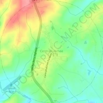
Name: Centralhatchee topographic map, elevation, terrain.

Location: Centralhatchee, Heard County, Georgia, United States (33.35397 -85.12141 33.38361 -85.08581)

Average elevation: 827 ft

Minimum elevation: 702 ft

Maximum elevation: 1,014 ft

Heard County trails, hiking, mountain biking, running and outdoor activities

Other topographic maps

Click on a map to view its topography, its elevation and its terrain.

Texas

United States > Georgia > Heard County

Average elevation: 846 ft

Franklin

United States > Georgia > Heard County

Average elevation: 732 ft

Houston

United States > Georgia > Heard County

Average elevation: 751 ft

Glenn

United States > Georgia > Heard County

Average elevation: 784 ft

Cooksville

United States > Georgia > Heard County

Average elevation: 696 ft

Viola

United States > Georgia > Heard County

Average elevation: 778 ft

Roosterville

United States > Georgia > Heard County

Average elevation: 991 ft

Owensbyville

United States > Georgia > Heard County

Average elevation: 702 ft

Glenloch

United States > Georgia > Heard County

Average elevation: 948 ft

Gear up for your next adventure:

📡Handheld GPS Device - Reliable handheld GPS for outdoor navigation
🌧️Backpack Rain Cover - Keep gear dry in wet weather
📻Weather Alert Radios - Stay informed of storm risks while off-the-grid
🦺Reflective Outdoor Gear - Safety gear for low‑light conditions
🌎3D Topographic Globes - Raised relief globes for a tactile understanding of geography

As an Amazon Associate, this site earns from qualifying purchases at no extra cost to you.