Ephesus topographic map
Interactive map
Click on the map to display elevation.
About this map
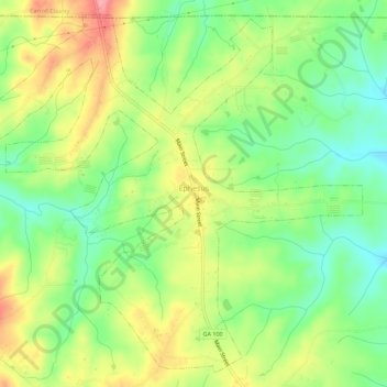
Name: Ephesus topographic map, elevation, terrain.
Location: Ephesus, Heard County, Georgia, United States (33.38467 -85.28597 33.42798 -85.22991)
Average elevation: 1,181 ft
Minimum elevation: 1,027 ft
Maximum elevation: 1,375 ft
Other topographic maps
Click on a map to view its topography, its elevation and its terrain.
Glenn
United States > Georgia > Heard County
Glenn, Heard County, Georgia, United States
Average elevation: 784 ft
Houston
United States > Georgia > Heard County
Houston, Heard County, Georgia, 30219, United States
Average elevation: 751 ft
Cooksville
United States > Georgia > Heard County
Cooksville, Heard County, Georgia, United States
Average elevation: 696 ft
Glenloch
United States > Georgia > Heard County
Glenloch, Heard County, Georgia, United States
Average elevation: 948 ft
Roosterville
United States > Georgia > Heard County
Roosterville, Heard County, Georgia, 30170, United States
Average elevation: 991 ft
Viola
United States > Georgia > Heard County
Viola, Heard County, Georgia, United States
Average elevation: 778 ft
Owensbyville
United States > Georgia > Heard County
Owensbyville, Heard County, Georgia, United States
Average elevation: 702 ft
Centralhatchee
United States > Georgia > Heard County
Centralhatchee, Heard County, Georgia, United States
Average elevation: 827 ft
Texas
United States > Georgia > Heard County
Texas, Heard County, Georgia, United States
Average elevation: 846 ft
Yellow Dirt
United States > Georgia > Heard County
Yellow Dirt, Heard County, Georgia, United States
Average elevation: 778 ft
Franklin
United States > Georgia > Heard County
Franklin, Heard County, Georgia, United States
Average elevation: 732 ft
Corinth
United States > Georgia > Heard County
Corinth, Heard County, Georgia, United States
Average elevation: 764 ft