Geolocate

Macieira de Rates topographic map

Click on the map to display elevation.

About this map

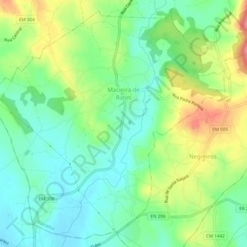
Name: Macieira de Rates topographic map, elevation, terrain.

Location: Macieira de Rates, Barcelos, Braga, Portugal (41.41764 -8.66032 41.45002 -8.61413)

Average elevation: 253 ft

Minimum elevation: 131 ft

Maximum elevation: 472 ft

Other topographic maps

Click on a map to view its topography, its elevation and its terrain.

Silveiros

Portugal > Braga > Barcelos

Average elevation: 446 ft

Fonte Coberta

Portugal > Braga > Barcelos

Average elevation: 384 ft

Monte do Facho

Portugal > Braga > Barcelos > Roriz

Average elevation: 397 ft

Vila Cova

Portugal > Braga > Barcelos

Average elevation: 322 ft

Feitos

Portugal > Braga > Barcelos

Average elevation: 850 ft

Milhazes

Portugal > Braga > Barcelos

Average elevation: 272 ft

Vilar do Monte

Portugal > Braga > Barcelos

Average elevation: 541 ft

Gonçalo

Portugal > Braga > Barcelos

Average elevation: 1,138 ft

Franqueira

Portugal > Braga > Barcelos

Average elevation: 479 ft

Martim de Além

Portugal > Braga > Barcelos > Martim

Average elevation: 440 ft

Durrães

Portugal > Braga > Barcelos

Average elevation: 433 ft

Gamil

Portugal > Braga > Barcelos

Average elevation: 223 ft

Gear up for your next adventure:

🚁Photography Drones - Capture stunning aerial views of landforms and topography
🪑Ultralight Camp Chairs - Portable seating for resting after a long day of mapping
🪄Magnetic Compass - Accurate compass for navigation
🔌Solar Panel Charger - Charge gear sustainably outdoors
🪶Fire Starter Kit - Reliable fire starter for survival and camping

As an Amazon Associate, this site earns from qualifying purchases at no extra cost to you.