Geolocate

Kipling topographic map

Click on the map to display elevation.

About this map

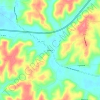
Name: Kipling topographic map, elevation, terrain.

Location: Kipling, Guernsey County, Ohio, 43750, United States (39.97618 -81.52068 40.01618 -81.48068)

Average elevation: 892 ft

Minimum elevation: 778 ft

Maximum elevation: 1,047 ft

Guernsey County trails, hiking, mountain biking, running and outdoor activities

Other topographic maps

Click on a map to view its topography, its elevation and its terrain.

Byesville

United States > Ohio > Guernsey County

Average elevation: 860 ft

Fairview

United States > Ohio > Guernsey County

Average elevation: 1,132 ft

Lore City

United States > Ohio > Guernsey County

Average elevation: 869 ft

Cumberland

United States > Ohio > Guernsey County

Average elevation: 902 ft

Gear up for your next adventure:

🛠️Backpacking Tool Kit - Essential toolkit for outdoor repairs
🚑Emergency Bivvies - Heat-reflective sleeping bags for survival situations
🛠️Outdoor Gear Repair Kit - Essential tools to fix gear on the trail
🥩Freeze-Dried Meals - Nutritious and lightweight food for remote expeditions
🧣Hiking Neck Gaiter - Multi‑use neck protection for outdoor weather

As an Amazon Associate, this site earns from qualifying purchases at no extra cost to you.