
Sueca topographic map
Click on the map to display elevation.
About this map
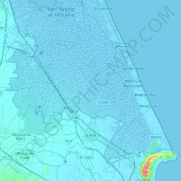
Name: Sueca topographic map, elevation, terrain.
Location: Sueca, la Ribera Baixa, Valencia, Valencian Community, Spain (39.16387 -0.36150 39.31521 -0.24460)
Average elevation: 13 ft
Minimum elevation: -20 ft
Maximum elevation: 732 ft
Other topographic maps
Click on a map to view its topography, its elevation and its terrain.
Desert de les Palmes
Spain > Valencian Community > Castelló / Castellón > Benicàssim / Benicasim
Average elevation: 1,214 ft
Vila-real
Spain > Valencian Community > Castelló / Castellón > Vila-real > Vila-real
Average elevation: 138 ft
Jardí botànic
Spain > Valencian Community > Castelló / Castellón > Todolella
Average elevation: 2,779 ft
Cim del Montnegro
Spain > Valencian Community > Castelló / Castellón > Borriol
Average elevation: 1,135 ft