Geolocate

Moraira topographic map

Click on the map to display elevation.

About this map

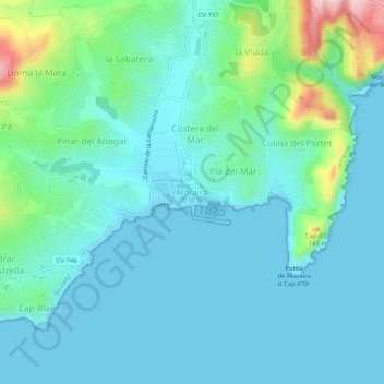
Name: Moraira topographic map, elevation, terrain.

Location: Moraira, Teulada, la Marina Alta, Alacant / Alicante, Valencian Community, 03724, Spain (38.66809 0.11446 38.70809 0.15446)

Average elevation: 131 ft

Minimum elevation: -3 ft

Maximum elevation: 735 ft

Other topographic maps

Click on a map to view its topography, its elevation and its terrain.

Elx / Elche

Spain > Valencian Community

Average elevation: 285 ft

Bocairent

Spain > Valencian Community

Average elevation: 2,477 ft

Tàrbena

Spain > Valencian Community

Average elevation: 1,873 ft

Aras de los Olmos

Spain > Valencian Community > La Serranía

The climate: due to its altitude, this land has cold winters and hot summers, although with mild nights. The snow can sometimes be seen, forming beautiful landscapes.

Average elevation: 3,173 ft

Titaguas

Spain > Valencian Community > La Serranía

Average elevation: 2,894 ft

el Campello

Spain > Valencian Community

Average elevation: 443 ft

Chelva

Spain > Valencian Community > La Serranía

Average elevation: 2,402 ft

Requena

Spain > Valencian Community

Average elevation: 2,283 ft

Bicorp

Spain > Valencian Community

Average elevation: 1,532 ft

Gilet

Spain > Valencian Community

Average elevation: 535 ft

Buñol

Spain > Valencian Community

Average elevation: 1,588 ft

Pedralba

Spain > Valencian Community > La Serranía > Pedralba

Average elevation: 581 ft

Paiporta

Spain > Valencian Community

Average elevation: 69 ft

Mutxamel

Spain > Valencian Community

Average elevation: 338 ft

Alfafar

Spain > Valencian Community

Average elevation: 20 ft

El Toro

Spain > Valencian Community

Average elevation: 3,658 ft

Utiel

Spain > Valencian Community

Average elevation: 2,877 ft

Sueca

Spain > Valencian Community

Average elevation: 13 ft

Serra

Spain > Valencian Community

Average elevation: 1,234 ft

Beniarrés

Spain > Valencian Community

Average elevation: 1,480 ft

Xàtiva

Spain > Valencian Community

Average elevation: 571 ft

Vilafamés

Spain > Valencian Community

Average elevation: 1,056 ft

Callosa d'en Sarrià

Spain > Valencian Community

Average elevation: 1,070 ft

Daimús

Spain > Valencian Community

Average elevation: 26 ft

l'Alfàs del Pi

Spain > Valencian Community

Average elevation: 331 ft

Anna

Spain > Valencian Community > Anna

Average elevation: 830 ft

Manises

Spain > Valencian Community

Average elevation: 213 ft

Rocafort

Spain > Valencian Community

Average elevation: 157 ft

Vila-real

Spain > Valencian Community

Average elevation: 138 ft

Simat de la Valldigna

Spain > Valencian Community

Average elevation: 879 ft

Cheste

Spain > Valencian Community

Average elevation: 804 ft

Benassal

Spain > Valencian Community > Castelló / Castellón

Average elevation: 2,956 ft

Sella

Spain > Valencian Community

Average elevation: 2,283 ft

Aín

Spain > Valencian Community > Castelló / Castellón > Aín

Average elevation: 2,090 ft

Gear up for your next adventure:

🧭Map Reading Tools - Tools and kits for map navigation
🌡️Handheld Weather Meters - Measure wind, temp, and pressure for safe mountain travel
🌐World Map Poster - Decorative world maps with topographic info
🪑Portable Camp Table - Compact table for campsite meals
🥾Women's Hiking Boots - Top-rated trail boots with ankle support and superior grip

As an Amazon Associate, this site earns from qualifying purchases at no extra cost to you.