
景阳镇 topographic map
Interactive map
Click on the map to display elevation.
About this map
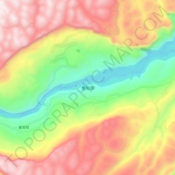
Name: 景阳镇 topographic map, elevation, terrain.
Location: 景阳镇, 建始县, 恩施土家族苗族自治州, 湖北省, 中国 (30.32753 109.96336 30.40753 110.04336)
Average elevation: 2,861 ft
Minimum elevation: 938 ft
Maximum elevation: 4,816 ft
Other topographic maps
Click on a map to view its topography, its elevation and its terrain.