
Korup National Park topographic map
Interactive map
Click on the map to display elevation.
About this map
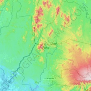
Name: Korup National Park topographic map, elevation, terrain.
Location: Korup National Park, Southwest, Cameroon (4.89207 8.71674 5.45732 9.26561)
Average elevation: 902 ft
Minimum elevation: 3 ft
Maximum elevation: 4,150 ft
Korup soils are generally coarse-grained, sandy, well drained and low in nutrients. Their acidic nature and low organic matter make them unfavourable sites for subsistence farming and cash-crop plantations, explaining the low levels of farming disturbance in the park, which remains mostly primary forest. The elevation of the park is low (50 m) in the southern section, rising steadily northwards with increasingly rugged terrain, reaching its highest point at Mt. Yuhan (1,079 m) near the old site of the now relocated Ikondokondo village. To the north, the terrain is characterized by low rolling hills with gentle slopes. Most (82%) of the park lies within an elevation of 120 to 850 m.
Other topographic maps
Click on a map to view its topography, its elevation and its terrain.
Mount Manenguba
Cameroon > Southwest > Kupe-Muanenguba > Bangem
Mount Manenguba, Bangem, Kupe-Muanenguba, Southwest, Cameroon
Average elevation: 6,929 ft
Kombo-Itindi
Cameroon > Southwest > Ndian > Kombo-Itindi
Kombo-Itindi, Ndian, Southwest, Cameroon
Average elevation: 13 ft
Korup CTFS plot
Cameroon > Southwest > Mudemba
Korup CTFS plot, Mudemba, Ndian, Southwest, Cameroon
Average elevation: 873 ft
Mount Cameroon
Mount Cameroon, Meme, Southwest, Cameroon
Average elevation: 11,959 ft