Make a donation
Gear up for your next adventure:
As an Amazon Associate, this site earns from qualifying purchases at no extra cost to you.
Spanish topographic map
Click on the map to display elevation.
Make a donation
Gear up for your next adventure:
As an Amazon Associate, this site earns from qualifying purchases at no extra cost to you.
About this map
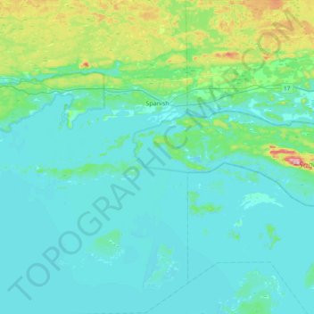
Name: Spanish topographic map, elevation, terrain.
Average elevation: 653 ft
Minimum elevation: 564 ft
Maximum elevation: 1,178 ft
Make a donation
Gear up for your next adventure:
As an Amazon Associate, this site earns from qualifying purchases at no extra cost to you.
Other topographic maps
Click on a map to view its topography, its elevation and its terrain.
Cedar Island
Canada > Ontario > Algoma District > Plummer Additional Township
Average elevation: 709 ft
Make a donation
Gear up for your next adventure:
As an Amazon Associate, this site earns from qualifying purchases at no extra cost to you.
Obakamiga River;Redfin Lake
Canada > Ontario > Algoma District > Unorganized North Algoma
Average elevation: 1,125 ft
The Three Sisters
Canada > Ontario > Algoma District > The North Shore Township
Average elevation: 791 ft
Make a donation
Gear up for your next adventure:
As an Amazon Associate, this site earns from qualifying purchases at no extra cost to you.
