Geolocate

Lakeview topographic map

Click on the map to display elevation.

About this map

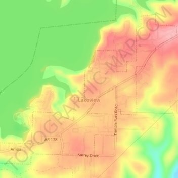
Name: Lakeview topographic map, elevation, terrain.

Location: Lakeview, Baxter County, Arkansas, 72642, United States (36.36328 -92.55860 36.38923 -92.52033)

Average elevation: 728 ft

Minimum elevation: 502 ft

Maximum elevation: 889 ft

Baxter County trails, hiking, mountain biking, running and outdoor activities

Other topographic maps

Click on a map to view its topography, its elevation and its terrain.

Gamaliel

United States > Arkansas > Baxter County

Average elevation: 751 ft

White River

United States > Arkansas > Baxter County

Average elevation: 486 ft

Buffalo City

United States > Arkansas > Baxter County

Average elevation: 577 ft

Clarkridge

United States > Arkansas > Baxter County

Average elevation: 787 ft

Shady Grove

United States > Arkansas > Baxter County

Average elevation: 702 ft

Gear up for your next adventure:

🥾Women's Hiking Boots - Top-rated trail boots with ankle support and superior grip
🧤Hiking Gloves - Protective gloves for rugged trails
🛠️Backpacking Tool Kit - Essential toolkit for outdoor repairs
🌐World Map Poster - Decorative world maps with topographic info
🗃️Trail First Aid Kit - Essential kit for outdoor injuries and emergencies

As an Amazon Associate, this site earns from qualifying purchases at no extra cost to you.