Geolocate

Rubiana topographic map

Click on the map to display elevation.

About this map

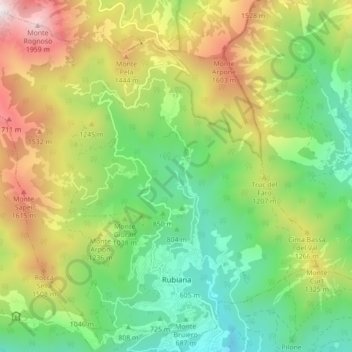
Name: Rubiana topographic map, elevation, terrain.

Location: Rubiana, Unione Montana Alpi Graie, Turin, Piedmont, Italy (45.12671 7.33228 45.18526 7.41947)

Average elevation: 3,425 ft

Minimum elevation: 1,421 ft

Maximum elevation: 6,683 ft

Other topographic maps

Click on a map to view its topography, its elevation and its terrain.

Sportinia

Italy > Piedmont > Turin > Sauze d'Oulx

Average elevation: 6,611 ft

Turin

Italy > Piedmont > Turin

Average elevation: 968 ft

Pratobotrile

Italy > Piedmont > Turin > Condove

Average elevation: 3,665 ft

Turin

Italy > Piedmont > Turin

Average elevation: 968 ft

Turin

Italy > Piedmont > Turin

Average elevation: 968 ft

Rivetto

Italy > Piedmont > Turin > San Giorio di Susa

Average elevation: 1,913 ft

Magnoletto

Italy > Piedmont > Turin > Condove

Average elevation: 2,293 ft

Suppo

Italy > Piedmont > Turin > Rubiana

Average elevation: 4,429 ft

Tornetti

Italy > Piedmont > Turin > Viù

Average elevation: 4,373 ft

Baio Dora

Italy > Piedmont > Turin

Average elevation: 1,621 ft

Famolasco

Italy > Piedmont > Turin

Average elevation: 1,667 ft

Morelli

Italy > Piedmont > Turin > Gravere

Average elevation: 2,575 ft

La Cialma

Italy > Piedmont > Turin > Locana

Average elevation: 5,594 ft

Belvedere

Italy > Piedmont > Turin > Borgiallo

Average elevation: 2,405 ft

Gear up for your next adventure:

🥾Hiking Shoes - Durable and comfortable shoes for trail hiking
🧭Compass with Lanyard - Easy‑carry compass for navigation
🧼Biodegradable Camping Soap - Eco‑friendly soap for outdoor hygiene
🪶Paracord Bracelet - Survival bracelet with built‑in tools
🧤Hiking Gloves - Protective gloves for rugged trails

As an Amazon Associate, this site earns from qualifying purchases at no extra cost to you.